Than Bok Khorani National Park
Contact Location : 2/2 Moo 2, Ao Luek Tai Sub-district, Ao Luek District, Krabi Province 81110
Telephone Number : (+66) 7 568 1096
Email : thanbokechorani.np@gmail.com
Facebook : Than Bok Khorani National Park
Information
-
Background
-
Note : After paying the entrance fee to the National Park, please carry the receipt for inspection.
65,000 rai (104 square kilometers)
|
|
|
|
|
|
|
|
|
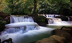
Nature trails ⇔ Visit Waterfall ⇔ Cave exploration/Geological condition ⇔ History/Culture ⇔ Observe flowers/plant ⇔ Bird/Butterfly ⇔ Snorkeling
Welfare shop : (coffee, drinks, snacks) open daily from 8.30 – 16.30 hrs.
National Park Headquarters : AIS, TRUE, DTAC
|
|
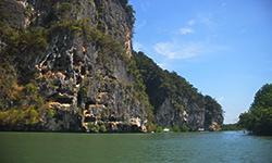
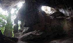
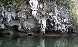
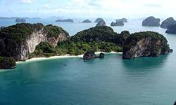
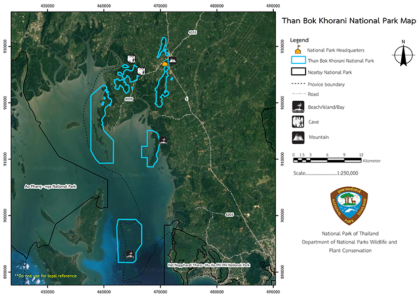
Some of the Than Bok Khorani National Park area has steep gradients with Karst Topography full of pits or sink holes prevalent. The range runs north to south. There are streams in the caves and undulating land surfaces . The Monadnock mountains are made of limestone and have cliffs which are scattered throughout the area, including Sa Yuan Thong Cave, Khuan Song, Khao Luk Ba, Talufa Cave, Khao Lot Tai, Khao Chong Lom, Khao Nok, Khao Ta Krot, Khao Ao Nam, Khao Ao Muang, Khao Sai To Dam, Khao Yai Pak Chong Lat. Islands in the Andaman include Ko Lao Bi Le (Ko Hong), Ko Lao Ka, Ko Lao Riam, Ko Pak Ka, Ko Lao La Ding, Ko Yala Hu Dang, Ko Lao Bulo Island (Ko Phak Bia), Ko Kamit (Ko Rai), Ko Pa Hu Sia, Ko Hantu, Ko Cha Bang, Ko Moei, Ko Ka Rot, Ko Taek, Ko Mi Lai (Ko Pe Lai), Ko Ao Chang Tai, Ko Lao Dua, Ko Rong Ma Rong (Ko Khlui), Ko Laem Khang Khao, Ko Laem Thalu, Ko Laem Tu Dot, Ko Chong Lat Tai and Ko Ham.
Soil group number 94, Takua Thung Series, and Bangpakong soil series. This soil group comprises the Takua Thung series and Bangpakong soil series, which are contiguous in terrain but without any relationship. When mapped it is impossible to distinguish the boundaries of each soil type because soil from the Takua Thung series can be located both above and below the Bang Pakong soil. Takua Thung Series: This is a fine-loamy, mixed-typic hydraquent formed by the deposition of seawater sediments. The area is smooth, with little or no gradient. There is a shallow layer of peat with poor drainage, and typically, the sea floods the area. The Department of Land Development (1986) report shows that the soil has a depth of not more than 20 centimater of loamy soil texture. The soil pH is moderately alkaline at about 8.0. The subsoil from 20 centimeters and below is a sandy loam, so is peat or peat-loam soil. The soil pH is moderately alkaline, with a value of about 8.0. The chemical analysis of this Takua Thung Series found that the upper soil was about 30 centimeters thick and had very high organic levels of matter content, and relatively high amounts of phosphorus and a potassium, which are beneficial to plants. The bottom level, from 30 centimeters downward, contains moderate amounts of phosphorus and has a very high level of potassium. In conclusion, this set of grounds includes a very high concentration of natural nutrients, but it has a bad physical appearance because of inferior drainage and flooded seawater. Bangpakong soil series: BPG is in the family of: fine, mixed, sulfaquents types of soil. The deposition of sea sediments created BPG series, which has gradients of zero to 1%. It is a league soil with poor drainage, so it floods with seawater. According to a report from the Department of Land Development (1986), the topsoil was not more than 15 centimeters deep. The soil texture is that of silty clay, and the soil reaction is s slightly acidic, with a pH of about 6.1. The bottom soil league is from 15 centimeters down and has a texture of silty clay to clay, and it becomes more acidic. The pH is about 6.0-2.3. The topsoil has very high organic matter content, including moderate phosphorus content and high potassium content beneficial to plants. The bottom soil contains moderate amounts of phosphorus and a very 3)Soil group number 85/Thasae and Khohong: Undifferentiated Soil Group: The Kh & Te The soil group consists of the Thasae and Khohong soil series. Kho Hong Series: Kh, Family: coarse-Loamysiticeous, typic Paleudults (USDA) iscreated by movement of textured sediment over a patio ledge river. It has undulations with gradients of 2-5%. It is heavy soil with good drainage, and it allows water to pass through quickly, as well as being strong enough to withstand rapid runoff on the surface. Generally, the groundwater level is more than 1 meter deep throughout the year, and according to the Department of Land Development (1986), the soil has 15 centimeters depth of sandy loam. The soil reaction is very acidic, and the pH is usually between 4.5 and 5.0. The bottom soil is sandy loam with clay particle numbers increasing the deeper you go. The soil is very acidic with pH ranged from 4.5 to 5.5. Based on the chemical analysis of this Kho Hong soil representative, the upper soil was about 30 centimeters thick with high organic matter content levels. It is deficient in phosphorus and low on potassium. The bottom soil in the league is only 30 centimeters deep and is also deficient in phosphorus and has very low amounts of potassium. In conclusion, this soil has low natural nutrients but good physical characteristics as it is a deep soil with good drainage. Tha Chae Series: Te, Family: Fine-Loamy, Mixed Typic Paleudults (USDA), It is caused by the deposition of the old alluvium or moving objects with rough sedimentary rocks on the patio ledge river at medium level. The condition of the area is undulating, with a slope of 3–5%, and is very league soil. It has good drainage, which means that the soil can allow water to pass through at a moderate speed and it is strong enough to allow rapid runoff of surface water. Commonly, the groundwater level is deeper than 1 meter. The Department of Land Development (1986) found that the dirt at a depth of not more than 20 centimeters has a sandy loam. The soil reaction is very acidic, and the pH is between 4.5 and 5.0. The subsoil is a sandy loam, very acidic, with a pH between 4.0 and 5.0. Based on the chemical analysis of the Tha Sae soil representative, the upper soil was about 30 centimeters thick with low organic matter content. It has low phosphorus content and low potassium content. In the subsoil of 30 centimeters or less, the potassium content is low. In conclusion, this soil has low natural nutrient content and relatively good physical characteristics because it is loam with good drainage. 4) Krabi and Lamphulaun differentiated soil group : Kbi & LV Soil group number 26 / Krabi and Lamphura Undifferentiated Soil Group: (KBI & LV) is a land utilization area for rubber and oil palm plantations outside of the Than Bok Khorani National Park area. It consists of the Krabi Series and the LamPhu La Series, which were created in contiguous terrain without any correlation to the nature of the area. When mapped it is not possible to distinguish the boundaries of each soil type. Krabi series: (Krabi series: Kbi) Family: Clayey; kaolinitic; typic Paleudults (USDA) Shale rock causes this soil group in the foothills to be mixed with residues of shale and phyllite. The terrain is undulating, and the rolling terraces can have gradients of up to 38%. It has good drainage and moderate water permeability. Typically, the groundwater levels are more than 1 meter deep throughout the year and he Department of Land Development (1986) stated the soil in the league did not exceed 20 cm, with loamy soil or clay loam and a dark brown to dark russet color. The soil is very acidic to moderately acidic, with a pH of between 5.0 and 6.0. The bottom soil has a clay texture and is either reddish yellow or dark brown. The soil is very acidic to moderately acidic with pH ranging from 5.0 to 6.0. Based on the chemical analysis of this soil representative, the upper soil was about 30 cm thick with a moderate amount of organic matter. The ground has a moderate potassium content and the soil nutrient content was low, but it has quite good physical characteristics with it being deep soil with good drainage. The set of grounds has no restrictions on coconut and rubber planting or being a pasture but it may not be suitable for rice cultivation due to a lack of water. Lamphula series: LI, Family: Clayey; kaolinitic; typic Paleudults (USDA) is created by the deposition of fine sedimentary rock, which is mostly shale. The condition of the area is relatively plain, with undulating slopes with gradients of between 2–5%. It is a relatively deep soil with good drainage, so it has moderate water permeability. Typically, the groundwater level is more than 1 meter deep throughout the year, and according to the Department of Land Development (1986), the soil in the league did not exceed 20 centimeters, with loamy soil or clay loam and a grayish-brown to yellowish-brown color. The soil is acidic with a pH of 5.0 to 5.5. The bottom soil has a clay texture or silty clay and is dark brown to yellowish-brown color. The soil reaction is acidic with a pH of between 5.0 and 5.5. Based on this soil representative's chemical analysis, the upper soil is about 30 centimeters thick with a very high content of organic matter. The phosphorus content is low, but the potassium content is very high. The subsoil from 30 centimeters downward has little phosphorus content and high potassium content. This soil has moderate natural nutrients and has good physical characteristics because it is a deep soil with good drainage, so it is unsuitable for rice growth due to water shortages. However, other crops have no restrictions |
|
Weather The climate characteristics are that of the tropical monsoon with two seasons, rainy and summer. Villagers have a saying, ”Rain eight four sun" means eight months of the rainy season and four months of summer. The rainy season starts from late April to December of every year with September the rainiest month.November has the lowest average temperature at around 26.4 degrees Celsius. Summer starts from mid-January to April with least rainfall in February. The hot summer is suitable for tourism with April being mainly dry and havingthe highest average temperature at about 29 degrees Celsius.
|
|
|
|
Forest and Wildlife Plant societies in National Parks can be classified into different areas as followed; Rainforests are found in steep mountain ranges and are home to Malacca Teak, Hopea pierrei Hance, Cotylelobium lanceolatum Craib, Lagerstroemia speciosa (L.) Pers., Lagerstroemia floribunda Jack ex Blume, Saraca indica Linn, Mangifera caloneura, Parashorea stellata Kurz, Dipterocarpus alatus, Tristaniopsis burmanica (Griff.) Peter G. Wilson & J. T. Ground plants and epiphytic plants include Salacca wallichiana (Gaertn.) Voss, Rattan, Wild Bamboo, Caryota urens, Mak Tao, Elephant Ear, ferns, Musa acuminata Colla and orchids. There are freshwater fish commonly observed in the creek, including Striped Snakehead Fish, Java Barb, Puntigrus partipentazona, Red Cheeked Barb, Minnow, Catfish, Blue Panchax, Eel Garden, Yellow Mystus, Moonlight Gourami, Trichopterus, Siamese Fighting Fish, Shortfinned Eel, Climbing Perch, Freshwater Garfish, and Hampala barb. Than Bok Khorani National Park covers approximately 64.3 square kilometers of seawater and is home to essential aquatic animals including shellfish, crabs, shrimp, Blue-Lined Coral Cod, Lutjanidae, Freshwater Butterfly Fish, Parrotfish, Damselfish, Red Lionfish, Clownfish, Sea-Cucumber, Sea Star, King Crab, Sea Anemone, Sea Urchin, sponges, soft corals, Staghorn Coral, Platygyra daedalea, and Mushroom Coral. |
How to get there by car :
From Krabi, take Highway No. 4 (Phetkasem Road) to Ao Luek District, Krabi Province. At the junction take local highway no. 4039 for 2 kilometers to reach the National Park Headquarters. The total distance from Krabi city is about 48 kilometers.
How to get there by plane:
Travel from Bangkok to Krabi flights from Don Mueang Airport then continue by car or bus from Krabi Bus Terminal to Than Bok Khorani National Park. There are many bus line options, such as regular buses, which cost 20 baht, or 30 baht for air-conditioned vans. It is then a distance of 2 kilometers from the bus stop, and tourists can get a pick-up truck or motorcycle taxi for around 10 baht.
How to get there by bus :
Using the Bangkok – Krabi route, which is a distance of 814 kilometers and costs around 300 baht in a regular bus and 450 baht for Air-Conditoned, with VIP buses from 1,486 THB . There is also a Super VIP option on a 24-seat bus for 650 baht. The bus trip takes about 10 hours and can drop off tourists at the Ao Luek intersection station. Then take a motorcycle taxi or a car taxi to Ao Luek Nuea-Ao Luek Tai to the park.
- National Park Ranger Station Tho Bo No. 1 (Ko Hong)
- National Park Ranger Station Tho Bo No. 2 (Laem Sak)
- Campsite services, tents, and equipment for rent

