Khao Luang National Park
Contact Location : Khao Luang National Park, Moo 4, Ban Ron, Khao Kaeo Sub-district, Lan Saka District, Nakhon Si Thammarat Province 80230
Telephone Number : (+66) 7 530 0494 , (+66) 7 530 0495
Email : Khaoluang2517@gmail.com
Facebook : Khao Luang National Park
Information
-
Background
Khao Luang National Park is assigned to Khao Luang Forest, and atotal of 14 forests are national parks. The Royal Forest Department conducted a preliminary survey about the conditions in the Khao Luang forest area after a windstorm in 1962, which felled many large trees. It was decided that the forest was suitable for conservation as a national park to benefit recreation, education, research, and the protection of wildlife species. Later, the National Park Board, in a resolution from meeting 1/2517, on January 22, 1974, agreed to establish a national park.
The royal decree specified the area of Khao Luang forest as being in Don Tako, Kathun, Phipun and Yang Khom Sub-district, Phipun District, Laai and Chang Klang Sub-district, Chawang District, Tha Ngio Sub-district, Mueang District, Phrom Lok, Ban Ko and Inthakhiri Sub-district, Phrom Khiri District, Khao Kaeo, Tha Di and Kamlon Sub-district, and Lan Saka District, in Nakhon Si Thammarat Province. The establishment was announced in the Government Gazette, Volume 91, Part 216, dated December 18, 1974. It became Thailand’s ninth national park in the country.
2. Location and Territory
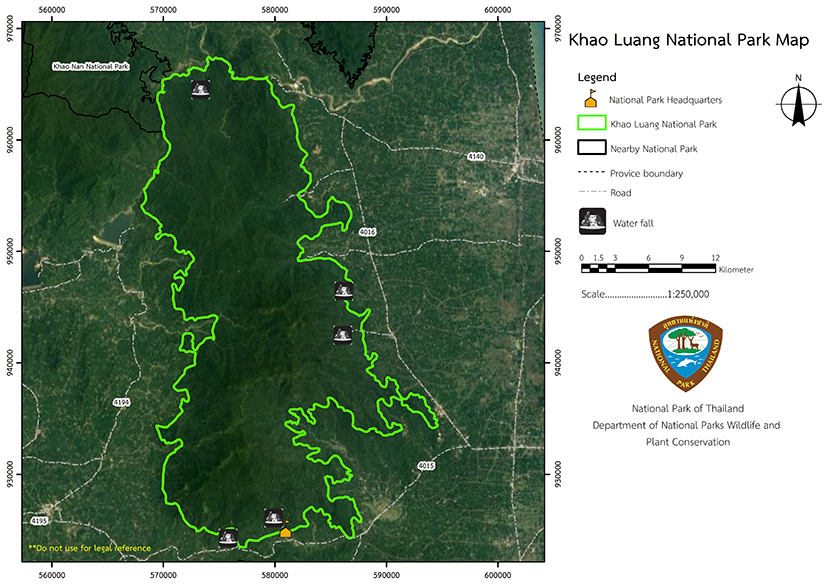
Khao Luang National Park is located in southern Thailand and is approximately 570 square kilometers or 356,250 rai in size. It is in the Phipun, Chawang, Chang Klang, Lan Saka, Mueang, Phrom Khiri and Nopphitam District, in Nakhon Si Thammarat Province, between latitudes of 8 degrees 22 minutes and 8 degrees 45 minutes north and between longitudes of 99 degrees 37 minutes and 99 degrees 51 minutes east.
The boundaries are as follows:
North: The Krung Ching National Reserved Forest and Khao Nan National Park
East: Phrom Khiri District
West: Phipun District and Plai Krabiat National Reserved Forest, Khao Kratoon Forest, Kra Thun Forest Wildlife Sanctuary
South: Lan Saka District
3. Transportation and Access to National Parks From Nakhon Si Thammarat province, take Highway
No. 4016 for distance of about 9 kilometers to the Tan House Intersection. Then turn left onto the Tan House route – Ban Song, Highway No. 4015, for 20 kilometers to the entrance to the Khao Luang National Park Headquarters (Namtok Ka Rom). Turn right and it is another 2 kilometers.
Note : After paying the entrance fee to the National Park, please carry the receipt for inspection.
356,250 rai (570 square kilometers)
|
|
|
|
|
|
|
|
|
Nature trails ⇔ Trekking ⇔ Visit Waterfall ⇔ Observe flowers/plant ⇔ Bird/Butterfly ⇔ History/Culture ⇔ Camping
Welfare shop: (coffee, drinks, snacks): open daily from 8.00 - 16.30 hrs.
National Park Headquarters: AIS, TRUE, DTAC
|
|
The topography of the Khao Luang National Park area covers the central Nakhon Si Thammarat Mountain range, which is a complex of high mountains stretching from north to south and parallel to the eastern seaboard. There are a few plains in the valleys, and the mountain soil is formed by erosion of the rocks and build-up of organic matter. The tallest peak is Khao Luang at 1,835 meters above sea level. It is the source of many streams, such as the Tapi River, Pak Phanang River, Krung Ching Canal, Khao Kaeo Canal, Tha Phae Canal, Ranae Canal, and La Ai Canal, which are important water sources for the surrounding area. Khao Luang National Park has its peak at Luang Summit at the elevation of 1,835 meter above sea level. Around 34.37% of the area has the elevations of 250-500 meters. The slope gradient ranges from 35-60%, accounting for 37.56% of the area. Water Resources, Watersheds Class, and Water Quality The primary river basin of Khao Luang National Park is the Tapi Basin which is served by tributaries that include the Tapi Ton Bon Basin, Khlong Klai Basin, Khlong Chan Di Basin, and the Southern Basin watershed on the east coast, group 4. The watershed quality in Khao Luang National Park is classified as follows: - Class 1A accounts for 58.77 percent of the area of 334.99 square kilometers. - Class 2, accounting for 21.25 percent of the area of 121.13 square kilometers. - Class 3, accounting for 8.92 percent of the area of 50.84 square kilometers. - Class 1B, accounting for 5.56 percent of the area of 31.69 square kilometers. - 1A.R, accounting for 2.87 percent of the area of 16.36 square kilometers. - Class 4 accounts for 1.51 percent of the area of 8.61 square kilometers. - Class 1B, accounting for 1.11 percent of the area of 6.33 square kilometers. - Class 5, accounting for 0.01 percent of the area of 0.06 square kilometers, respectively. - Most of the canals in Khao Luang National Park are long canals flowing to converge in Phunphin District, Surat Thani Province. The tributariesconsist of the Chan Di Canal, Sin Pun Canal, I Pan Canal, Sok Canal, Phra Saeng Canal, and Phum Duang Canal, which originates from Nuea Fa Waterfall, Phipun District, Nakhon Si Thammarat Province, and flows into the river at Phunphin District, Surat Thani Province, and then into the Gulf of Thailand. |
|
Climate Rainfall, temperature, relative humidity, wind speed, and the amount of water evaporation of the area obtained from the weather station in Nakhon Si Thammarat province are as follows: 1. Average temperature: Climatic characteristics of the Khao Luang National Park area are under the southeast monsoon’s influence. 2. Relative Humidity The weather station in Nakhon Si Thammarat Province found that the monthly average humidity tends to be high, indicating a large amount of water vapor in the air without high variation. The relative humidity ranged from 86 percent in November to 70 percent in July and August, and the average annual relative humidity was 79 percent. The maximum monthly average relative humidity was 96 percent, and the minimum was 57 percent. 3. Wind: The weather station is in Nakhon Si Thammarat Province. The southwest monsoon from May to October has a direction from the southwest. When the southeast monsoon influence weakens and the high-pressure impact from the north is strong, the wind shifts to the north and east mostly. 4. Rainfall: The average annual rainfall is 2,381.3 millimeters with the highest monthly average of 643.1 millimeters in November. The most in 24 hours was 447.8 mm, and rain fell on 22 days in November 5. Evaporative Volume of Nakhon Si Thammarat Province’s Weather Station: There is a low variance in the monthly average evaporation volume. The lowest monthly average evaporation volume was 84.7 mm in March, less than during the rainy and winter months. The value may be higher in the summer, from February to May. 6.Wind Speed: The average wind speed is lowe throughout the year, and the highest wind speeds in the past 30 years were in April |
|
|
|
|
Forest and Wildlife Khao Luang National Park is a mountainous area with elevations of approximately from 100 meters up to 1835 meters above sea level. It has a peninsular climate with rain all year round due to the high mountainous area and humidity. The average rainfall is relatively high.It is mainlytropical rainforest and the ecosystem in the Khao Luang National Park can be classified as follows: Plant Community 1. A tropical rain forest or tropical evergreen forest is a forest with a dense canopy of large trees and an understory layer that covers the entire national park. Endemic plant species which are economically significant include the Dipterocarpaceae family, with the rubber tree family (Dipterocarpus spp.), Hopea odorata (Hopea Odorata), Parashorea stellata Kurz (Parashorea Stellata), Shorea Gratissima(Shorea gratissima), Shorea leprosula (S. Leprosula), Shorea onjugat(S. Ferinosa), Mesawa (Anisoptera Costata), Vatica odorata (Griff.) Symington subsp. Odorata) (Vatica cinerea). Other trees include Malacca Teak (Intsiapalembanica), Neolitsea zeylanica Merr. (Neolitsea zeylanica), Cinnamomum iners Reinw. Ex Blume (Cinnamomuminers), Cinnamonbejolghota (C. bejolghota), Cinnamomum porrectum (C. porrectum), Champak (Michelia champaca) Aglaia andamanica (Aglaia andamanica), Eugnia onjugate (Eugnia onjugate), Heritiera javanica (Blume) Kosterm. (Hertiera javanica), Hertiera sumatrana (H. Sumatrana), Toona tebrifuga (Toona febrifuga), Ailanthus triphysa (Ailanthus triphysa), Koompassia excelsa (Becc.) Taub. (Koompassia excelsa), Horsfieldia grandis and Nageia wallichiana (C. Presl) Kuntze (Podocarpus wallichianus) Rare plant species include the Giant Fishtail Palm (Caryota obtuse). Various types of rattan are found including - Genus Calamus includes Calamus javensis (Calamus javensis), Calamus scipionum (C. scipionum), Calamus bousigonii (C. bousigonii), and Calamus longisetus (C. longisetus) - Genus Daemonorop includes Deamonorops brachystachys. (Deamonorops brachystachys), Daemonorops grandis (D. grandis), and Daemonorop kunstleri (D. kunstleri). - Genus Korthalsia includes Korthalsisa grandis, or The Three Equal Sepal Renanthera Korthalisa grandis (Korthalisa grandis) and Korthalsia rigida (K. rigida). The bamboos found in the genus are as follows: - Genus Gigantochloa includes Gigantochloa hasskarliana (Gigantochloa hasskarliana), Gigantochloa Apus (G. Apus). Genus Schizostachyum includes Schizostachyum blumei (Schizostachyum blumei) and Schizostachyum brachycladum (S. brachycladum). - Rare plant species such as Caryota gigas Hahn ex Hodel are now drastically reduced and may be extinct soon due to changes in their environment. The endemic ferns found at Khao Luang National Park consist of Dipteris conjugata Reinw. (Dipteris conjugate) and Cheiropleuria bicuspis (Cheiropleuria bicuspis). A critical and endemic plant that is only found in Nakhon Si Thammarat province is the Rhododendron taiense Rhododendron taiense. The Planted Community consists of agricultural areas includes Rubber Tree (Hevea braciliensis), palms ( Areca catechu), coconuts (Cocos nusifera), Durian (Durio zibethinus), Coffea robusta (Coffea robusta,), Mangosteen (Garcinia mangostana), Jackfruit (Artocarpus hetterophyllus), Champada (A. Integer), Rambutan (Nephelium lappaceum), Langsat (Lansium domeatica), Bitter bean (Parkia speciosa), Pepper (Piper nigrum) and Betel Vine. (P. Betel).
Wildlife The species can be divided according to the Wildlife Preservation and Protection Act, B.E. 2535, as follows: Two species of wild animals in Thailand are the Chamois (Capricornis sumatraensis) and the Tapir (Tapirus indicus). Protected animals including Southern Pig-Tailed Macaque (Macaca nemestrina), Asian Brush–Tailed Porcupine (Atherurus), Clouded Leopard (Neofelis nebulosa), and Black-Footed Leopard (Panther), Indian muntjac (Muntiacus muntjak), Deer (Cervus Unicolor), Bagheera (Panthera pardus), Bengal Tiger (P. tiger), and Wildlife classified by IUCN red categories (Humphrey and James R. Bain, 1990) are as follows: Threatened species: 15 species including Southern Pig-Tailed Macaque (Macaca nemestrina), Stump-Tailed Macaque (M. arctoides), Ursus malayanus (Helarctos malayamus), Banded Surili (P. melalophos), Dusky Leaf Monkey (P. obscura) and endangered speciessuch as Serows (Capricornis sumatraensis), Tapirs (Tapirus indicus), Bagheera (Panthera pardus), and White-Handed Gibbon (Hylobates lar). 2. Birds: 157 species from 37 families.143 species are endemic to Thailandand 14 species are winter visitors, which can be classified as follows: Protected animals Type 2 include the Red Junglefowl (Grallus gallus), Thick-Billed Green Pigeon (Treron curvirostra) Others Birds classified by IUCN red categories (Humphrey and James R. Bain, 1990) are as followed: Threatened: Six speciesof the Black Eagle (Ictinaetus malayansis), Crested Fireback (Lophura ignifa), Great Argus (Argusianus argus), and White-Crowned Hornbill. (Berenicornis comata), Bushy-Crested Hornbill (Anorshinus galeritus), and Great Hornbill (Buceros bicornis). Endangered: Two species are threatened: the Helmeted Hornbill (Rhinoplax vigil) and the Red-Crowned Barbet (Megalaima raffesii). Reptiles: 40 species, 11 families From the survey, one species exists only in the Khao Luang area, which is the Malayan Mountain Keelback (Amphiesma inas). The rest of the species include Spiny Turtle (Heosemys spinosa), Red Blood Python (Python curtus), and Red-headed Krait (Bungarus flaviceps). The species found only in Thailand are Kumpol’s Rock Gecko (Cnemasopis kumpoli), Eastern Bent-Toed Gecko (Crytodactylus brevipalmatus), Lyzosoma herberti , and Banded Cat Snake (Boiga saengsomi). 4. Amphibians: 12 species in 5 families The Mahogany Frog (Rana Luctuosa) is a species only found in Khao Luang National Park and the species only found in Thailand is Supachai’s Caecilian (Ichthyophis Supachaii). A rare species is the Tenasserim Frog (Ingerana tenasserimensis), 5. Aquatic animals include 16 species from8 families of fish, and 2 species of crabs. The water source in the national park has low amount of nutrient with strong currents and base that is not suitable for the aquatic animals’ habitats. As a result, only certain species can adapt to such environments |
How to get there by car :
Visitors can travel by plane, train, or car from Nakhon Si Thammarat town, whihc is approximately 800 kilometers from Bangkok. The journey to Khao Luang National Park starts from Nakhon Si Thammarat town, from where you take provincial highway 4015 towards Lan Saka District for about 20 kilometers. Khao Luang National Park Headquarters (Namtok Ka Rom) are about 1km inside.
- Khao Luang National Park Headquarters
- National Park Ranger Station Kho Lo No. 1 (Namtok Phrom Lok)
- National Park Ranger Station Kho Lo No. 2 (Namtok Ai Khiao)
- National Park Ranger Station Kho Lo No. 3 (Namtok Krung Ching)
- National Park Ranger Station Kho Lo No. 4 (Namtok Suan Ai)
- National Park Ranger Station Kho Lo No. 5 (Namtok Tha Phae)
- National Park Ranger Station Kho Lo No. 6 (Namtok Suan Khan)
- National Park Ranger Station Kho Lo No. 7 (Namtok Yot Lueang)
- National Park Ranger Station Kho Lo No. 8 (Namtok Nuea Fa)
- National Park Ranger Station Kho Lo No. 9 (Nopphitam – Pak Khlong Kung Ching)
Accommodation : Khao Luang 201 (Sao Yut)
Khao Luang 204/1-4 (Bu Nga)
Khao Luang National Park has lodges, camping grounds, tents, and equipment rental services, together with food and drink, are available.

