Namtok Si Khit National Park
Contact Location : Namtok Si Khit National Park, Moo 2, Si Khet Sub-district, Sichon District, Nakhon Si Thammarat Province 80120
Telephone Number : (+66) 7 580 5500
Email : sikit2518@hotmail.com
Facebook : Namtok Si Khit National Park
Information
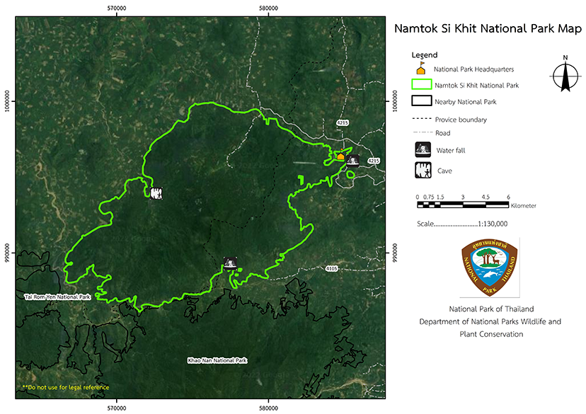
In the past, the forest area was dense and abundant with wildlife and therefore scary, so on thethe local villagers gave it a terrifying“ name, "Phi Khit," which means ghost of the cross, and later was distorted to Si Khit. There are limestone mountains in the Namtok Si Khit National Park, which have formed beautiful limestone waterfalls and stunning caves. The park covers approximately 90,625 rai, or 145 square kilometers, and they are located in the steep and complex Nakhon Si Thammarat Mountain range. There is a watershed dividing the provinces of Nakhon Si Thammarat and Surat Thani.
In the past, the area around Si Khit Waterfall was in the Yang Phong and Khao Yai National Reserved Forest in Si Khit Sub-district, Sichon District, Nakhon Si Thammarat Province. It is an area with beautiful natural scenery such as waterfalls, islands, water basins, rocks, and many different plant families, and as such it was put forward to be developed as a place of recreation. Nakhon Si Thammarat province has designated this area as a tourist attraction in the Sichon District, and in responsethe district campaigned for a community forest conservation project for the Si Khit Waterfall area and proposed to the Royal Forest Department the establishment ofa forest park, in order to maintain the beautiful landscape and conserve the watershed areas for people to use in agriculture.
The forest area near the waterfall has been encroached upon by people who wish to cultivate the land and therefore destroy the forest. In this regard, Mr. Chamni Bunyopas, Director-General of the Royal Forest Department, approved the establishment of an area around Si Khit Waterfall in the Yang Phong and Khao Yai National Reserved Forests. It was agreed it would become a Forest Park in September 1986, but its operations were halted due to budgetary constraints until 1989, when budget was allocated.
The National Reserved Forest areas of Yang Phong Forest and Khao Yai Forest cover approximately 60,625 rai (97 square kilometers). There are many beautiful natural features, such as Si Khit Waterfall, Samnak Nian Waterfall, Khao Phap Pha Cave, and Suan Prang Cave. It is also a critical watershed source for the agriculture of Sichon District, Nakhon Si Thammarat Province, and is a habitat for abundant wildlife. At the same time, in the current situation, the area has been extensively invaded by people who want to clear the forest and occupy the land. Hence, the Royal Forest Department created order 584/2532, dated April 14, 1989, for Mr. Sompol Silpatheerathorn, Forest official 4 under the National Park Division, to perform regular duties as the Head of the Namtok Si Khit Forest Park and to conduct additional surveys on possibly suitable nearby areas for consideration as national parks.
This survey covered nearby forest areas in Surat Thani province, namely, Chai Kram and Wat Pradu National Reserved Forest on the west side of Yang Phong and Khao Yai National Reserved Forest.
Background
-
Note : After paying the entrance fee to the National Park, please carry the receipt for inspection.

90,625 rai (145 square kilometers)
|
|
|
||
|
|
|||
Nature trails ⇔ Visit Waterfall ⇔ Observe flowers/plant
Welfare shop : (drinks, food, snacks): Open daily from 8.30 - 16.30 hrs.
National Park Headquarters: AIS, TRUE
|
|
The topography of the Nakhon Si Thammarat Mountaion the range is that of plains interspersed with steep mountains, which are part of the Nakhon Si Thammarat Mountain Range (Banthat Mountain range) and it forms the border between Surat Thani Province and Nakhon Si Thammarat Province. It is located in Kanchanadit and Sichon District, and the mountains are run on a north-south axis, parallel to the eastern seaboard. The central part is a complex of steep mountain ranges and watersheds with low slopes to the east and west, and most of the plains are in the east. This area has the highest peak at Khao Kee Mode, at 1,303 meters above sea level. Other mountains consist of Khao Nang which is 881 meters above sea level, Khao Wang Phung Peak at 600 meters above sea level, Khao Plai Khram Peak, at 599 meters above sea level. high, and Khao Khun Huai Kaeo Peak, 582 meters above sea level. The average elevation is 700 meters above sea level. The valleys are home to many creeks, which create sequential pools and waterfalls. Some hills are limestone mountains and contain many incredible and beautiful caves, such as Khao Phappha Cave, Suan Prang Cave. |
|
Namtok Si Khit National Park is located on the Malay Peninsula, which receives monsoon winds blowing across the sea on both sides, and therefore has rainfall throughout the year. The rainy season runs from May-January, with most rainfall in November. The summer season is from February to April. The average temperature throughout the year is 27.3 degrees Celsius with he highest temperature in April at 33.8 degrees Celsius and the lowest in January at 21.8 degrees Celsius.
|
|
|
|
|
Namtok Si Khit National Park is a highly complex, folded mountain area with extensive territory. The elevations are between 100 to 1,303 meters above mean sea level The area is located in a pennisula under effects of monsoon, thus humid and high precipitation. The plant society is mostly those of tropical rain forest, with various denses species. The ecosystem ’ findings are classified as follows: The Tropical Rain Forest is dense in the top canopy and understory layers and covers most of the national park area, including the valleys and creeks. It can be divided into two subgroups according to elevation, which are : A lowland tropical rain forest appears in the flat areas along the creeks and valleys, It is at heights lower than 300 meters above sea level The upper canopy is 30 to 50 meters high, and the important plant species consist of Dipterocarpaceae family, Hopea odorata, Hopea pierrei Hance, Malacca Teak, Shorea roxburghii G.Don, and Parashorea stellata Kurz. The understory layer is at 15 to 30 meters and the tree species found include Mai Yang Rad, Great elephant apple, Lithocarpus siamensis A.Camus. , and Castanopsis inermis (Lindl.) Benth. & Hook.f. The lowest level has plants with heights of 5–15 meters, and the plants found there consist of Watery Rose Apple, Nephelium hypoleucum Kurz, Chinese Lantern Tree, Avenga pinnata, and seedlings of the upper canopy tree and shrub. The shrub species include Magnolia siamensis (Dandy) H. Keng, Tiliacora triandra Diels, Zingiberaceae, vines, rattan, Lagerstroemia duperreana Pierre ex Gagnep., Freycinetia sumatrana Hemsl., Pothos chinensis (Raf.) Merr., Willughbeia edulis Roxb., The Three Equal Sepals Renanthera, Calamus javensis, Calamus longisetus, and Calamus peregrinus. 2. A mid-elevation tropical rain forestis a forest that occurs in an area at an altitude of between 300 and 1,000 meters above sea level. The upper canopy is 30–50 meters high, and the important plant species consist of those Dipterocarpaceae family, such as Dipterocarpus costatus Gaertn. f., Dipterocarpus turbinatus C. F. Gaertn., and Dipterocarpus gracilis Blume. Therefore, it is also called the Rubber Hill Forest.The understory layer has A height of 15–30 meters and the tree species found include Podocarpus neriifolius D.Don, Ko Rean (Fagaceae), Ko Lek (Fagaceae), Pentace floribunda King, Caryota gigas Hahn ex Hodel, Mai Sai, and Aglaia odoratissima Blume. The lower level has plants with heights of 5–15 meters, and the plant life consists of shrubs and cover crops. These include the Phlong family (Memecylon sp.), the Ginger family (Zingberaceae), the Acanthaceae family (Acanthaceae), and ferns such as Cyathea podophylla, or Cyathea arborea., Various types of vines and rattan include Pleutail elongata Mart. & Blume utailCalamus myrianthus Becc, Dendrobium lindleyi or Calamus insignis, and Calamus rudentum Lour, Calamus bousigonii. The Hill Evergreen Forest is a forest at an elevation of more than 1,000 meters above sea level which can reach into the cloud level, which has high humidity. The canopy level is relatively consistent, at about 8–15 meters high, with moss and ferns on the trunks. Important plants that have been explored include Memecylon Edule Roxb ., Siam Benzoin, Mezzetta parvilflora Becc., Bang Tan, Waterkanon,utaileihomboidea, Lithocarpus sp., Lithocarpus rassa. Lower leveutails inlcude Ardisia fulva King & Gamutail. ciliata H.R.Fletcher, Malabar gooseberry, and Chloranthus spicatus. Ground plants are dense with moss and ferns as well as rare herbaceous plants such as Reissantia indica (Willd.) N. Halle and ground orchids. Secondary forests are alternative plant communities that replace the original forests after human invasion. The pioneer species include Mallotus paniculatus Mull.Arg., Firmiana colorata, Mallotus barbatus Müll.Arg., Trema orientalis (L.) Bl., Aquilaria malaccensis Lamk., and Alstonia macrophylla |
From Nakhon Si Thammarat province, take Highway No. 401, for 69 kilometers, to the Sichon District Intersection (Ton Phayom Intersection), and then turn left for 15 kilometers to the Namtok Si Khit National Park Headquarters.
From Surat Thani Province, take Highway No. 401 for 52 kilometers, to the Khao Hua Chang intersection. Turn right and go 10 kilometers to the Namtok Si Khit National Park Headquarters.
- National Park Ranger Station So Kho No. 1 (Suan Prang)
- National Park Ranger Station So Kho No. 2 (Samnak Nian)
- National Park Ranger Station So Kho No. 3 (Khuan Raboet)
Accommodation in Namtok Si Khit National Park is available in lodges and camping grounds, for which tents and rental equipment are available. There is also a restaurant.


