Kaeng Krung National Park
Contact Location : Kaeng Krung National Park, Moo 8, Takuk Nuea Sub-district, Vibhavadi District, Surat Thani Province, 84370
Telephone Number : (+66) 9 0878 0774
Email : kaengkrungpark@gmail.com
Facebook : Kaeng Krung National Park
Information
-
Background
The Electricity Generating Authority of Thailand was building a dam at Kaeng Krung in the Tha Chana forest, causing encroachment on the area around the reservoir. The Royal Forest Department issued order 1169/2532, dated July 31, 1989, for Mr. Dechawut Sethapun, Forest Scholar 5, to explore and collect preliminary data from the Kaeng Krung Reservoir, Tha Chana National Reserved Forest, and the Khlong Sok - Khlong Saeng - Khlong Yan Preserved Forests in Surat Thani Province.
The survey results show that the fertile, tropical Rain forest contains valuable trees and abundant wildlife, and that it is the source of water for Surat Thani and Chumphon Provinces.
Subsequently, the Royal Forest Department issued order 892/2532, dated November 24, 1989, for Mr. Dechawut Sethapun to conduct additional surveys and establish the Tha Chana National Reserved Forest and preserved forests of Khlong Sok, Khlong Saeng and Khlong Yan in Surat Thani Province as a National Park.
Later, Mr. Dechawut submitted report Ko So 0713/extraordinary, dated December 26, 1989, to the National Park Division (Royal Forest Department), and deemed it appropriate to use Khlong Yan National Park for the necessary canals, which were to be a prominent feature in the area.
The National Park Division considered using the name "Kaeng Krung National Park" and the Royal Forest Department proposed to the National Parks Board 1/2533, that it is appropriate to enact a royal decree specifying Tha Chana forest in Khan Thuli, Khlong Pha, Samo Thong and Prasong Sub-district, Tha Chana District, Pak Mak Sub-district, Chaiya District, Pak Chalui Sub-district, Tha Chang District, and Takuk Nuea, Vibhavadi Minor District, Surat Thani Province as Thailand’s 69th National Park on December 4 when it was published in the Government Gazette, Volume 108, Part 211. It covers an area of approximately 338,125 rai, or 541 square kilometers.
Note : After paying the entrance fee to the National Park, please carry the receipt for inspection.
338,125 rai (541 square kilometers)
|
|
|
|
|
|
|
|
|
Nature trails ⇔ Trekking ⇔ Visit Waterfall ⇔ Swimming ⇔ Observe flowers/plant ⇔ Bird , butterfly , wildlife watching activities ⇔ Take a photo/Video ⇔ Camping ⇔ Relax in a natural
Welfare shop : not available
National Park Headquarters : AIS
|
|
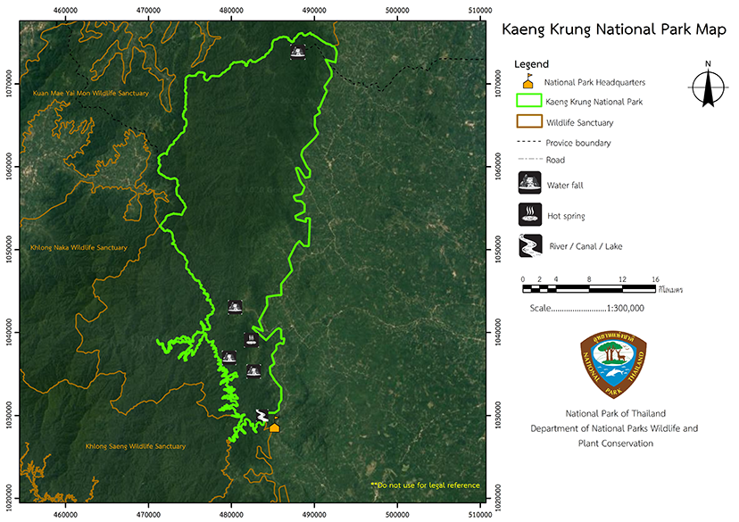
Kaeng Krung National Park is divided into several complex mountain landscape areas running on a north-south axis. Surat Thani province's western border is connected to Ranong province, and the mountains that run through the heart of Kaeng Krung National Park are located between the Lang Suan and Khlong Yan rivers. Khao Daen, Khao Yai Mon, Khao Nom Sao and Khao Phai are the four significant high peaks, with Khao Daen being the highest at approximately 849 meters above sea level The majority of the area is mountainous andTin ore is an abundant mineral in this area. The Nom Sao Summit has the highest elevation in Kaeng Krung National Park at 913 meters above sea level. 64.2% of the area is between 250 and 500 meters high, followed by 37.11% at 250–500 meters, and 10.77% below100 meters. The gradients are 34.376 degrees on average, ut 79.65 %, with most of the area having a slope of between 35 and 60 percent, accounting for about 40.685 percent of the area Geology and Soil Mineral and geological features found in Kaeng Krung National Park consist of one mineral set, covering 2.179 percent of the Kaeng Krung National Park area. 2.117 percent of the mineral collection was tin. Soils in Kaeng Krung National Park can be classified as Tha Uthen Series (Tu) at 88.66%, Damnoen Saduak Series (Dn) at 7.48%, Cha-am Series (Ca) at 2.53%, Cha Cheng Sao Series (Cc) at 1.30%, and Kula Rong Hai Series (Kl) at 1.03%. Soil group 62 is found on the complex slopes or in mountain areas with a pitch higher than 3%. The soil properties are uncertain but are not suitable for agriculture. This soil group covers 340,585.606 square kilometers or 99.619% of the National Park, which was supposed to be reserved as a forest area. Soil group 34 is in the Rueso soil series (Ro) which has soil characteristics of loam or silt caused by river sediments. The soil layer is relatively deep, with moderate drainage. The soil reaction is strongly acidic and of medium fertility, but some areas with this soil may have water shortages or flash flooding. Water Resources The main watersheds of Kaeng Krung National Park consist of the eastern side of Southern Basin, the western side of Southern Basin, and Tapi River Basin, which are the 4tributariesof the Lang Suan Basin, Lower Phum Duang Basin, Southern Basin on the East Coast Group 2, and the Upper Southern Basin on the West Coast. Characteristics of the Waterways around Kaeng Krung National Park - The Wai Canal and Yan Canal flow into Khlong Phum Duang and the Tapi River. - The Pak Mak Canal, Hin Lak Canal, and Tha Mai Daeng Canal flow into the Pak Mak Canal which flows down into Saiya District. - The Rok Canal, Song Canal, Sot Canal, and Tha Chana Canal flow into the Tha Krachai River in Tha Chana District. The amount of water from all tributaries is about 547 square kilometers. The average rainfall over a period of 30 years is approximately 138.86 mm. Simulations (Figure 8) show that the year-round water volume of streams is approximately 7.92 million cubic meters. or accounted for approximately 138.86 millimeters in height, equivalent to a valuation of approximately 38.3 million cubic meters of water production. The highest tide was 38.3 million cubic meters in August. while the low tide was 5.13 million cubic meters in March. |
|
The climate in the park has high humidity and is influenced of the southwest and northeast monsoons. Therefore, there are only two seasons, summer, which runs from February to April, and the rainy season, which runs from May to January.
|
|
|
|
Kaeng Krung National Park has a complex, folded mountainous terrain with abundant rainfall and a dense, tropical rain forest.The economically valuable trees include large perennials such as Malacca Teak, Orange champak, Hopea odorata and Dipterocarpus. The ground plants consist of shrubs, ferns, and various rattans. Wild animals living in Kaeng Krung National Park include wild elephants, tigers, bears, Bos Gaurus, Banteng, Tapir, Mouse Deer, gibbons, monkeys, langur, Wild Boar, Stump-Tailed Macaque, Raffle's Banded Langur, reptiles, and various birds such as the Bulbul, Helmeted Hornbill, Crow-Billed Drongo, Great Hornbill, Great Argus, Asian Fairy-Bluebird, and Red Junglefowl.
|
How to get there by car :
Bangkok to Surat Thani is about 600 kilometers in a car. At the Vibhavadi Sub-district intersection, pass through Mu Ban Thanying, and enter the Kaeng Krung National Park Headquarters. The about 54 kilometers, with another 13 kilometers on gravel roads.
National Park Ranger Station Ko Ko No. 1 (Thap Saming)
National Park Ranger Station Ko Ko No. 2 (Sai Kao Khon)
National Park Ranger Station Ko Ko No. 3 (Rai Yao)
National Park Ranger Station Ko Ko No. 4 (Khlong Pha)
National Park Ranger Station Ko Ko No. 5 (Bang Cham)
National Park Ranger Station Ko Ko No. 6 (Thap Tha Han)
National Park Ranger Station Ko Ko No. 7 (Khlong Yan)
- Kaeng Krung National Park does not have lodges but it does have camping grounds. There is no welfare shop or restaurant.

