Phu Soi Dao National Park
Contact Location : Phu Soi Dao National Park, Huai Mun Sub-district, Nam Pat District, Uttaradit Province 53110
Telephone Number : (+66) 9 5629 9528, (+66) 9 1024 7633
Email : phusoidao07@hotmail.com
Facebook : Phu soi dao National Park
Information
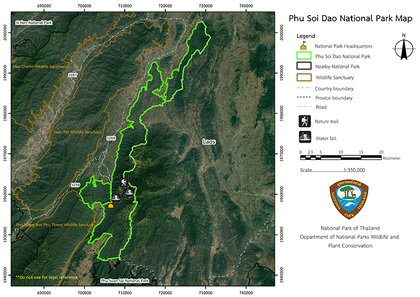
Phu Soi Dao National Park encompasses the Nam Pat National Reserved Forest in Muang Chet Ton, Na Khum and Ban Khok Sub-district, Ban Khok, Huai Mun, and Nam Pat District in Uttaradit Province, Bo Phak Sub-district, and Chat Trakan District in Phitsanulok Province. It is a relatively densely forested area that is the source of numerous waterways and also hosts attraction for visitors, such as the Phu Soi Dao Waterfall. which is a five-tiered waterfall covering an area of approximately 1,000 rai. The area is very beautiful with many paved roads for visitors to travel and relax on comfortably. The total area of Phu Soi Dao National Park is approximately 212,633 rai or 340 square kilometers.
Background
Phu Soi Dao National Park was originally Phu Soi Dao Forest Park whichwas establishedin 1990 with an area of only 20,000 rai. In 1992, instruction was given to explore additional areas that could be integrated with the original Phu Soi Dao Forest Park. Possible areas, such as Nam Pat National Reserved Forest in Nam Pat District, Uttaradit Province and in the permanent forest area along Phu Soi Dao Forest in Nam Pat District, Uttaradit Province, Phu Soi Dao forest in Chat Trakan District, Phitsanulok Province were put forward to create atotal area of 48,962 rai or 78 square kilometers.
The Phu Soi Dao Forest Park was established as Phu Soi Dao National Park in 1993, covering areas of in Nam Pat National Reserved Forest in Nam Pat District, Uttaradit Province, and Phu Soi Dao Forest at Chat Trakan District in Phitsanulok Province. These are areas of permanent forest with relatively complete and natural conditions. ’It is also a water catchment area for many waterways, and the terrain is primarily composed of tower karst mountains, the tallest of which is 1,600m above sea level. As a result, it is home to much wildlife.
The border area with Laos is a critical area for national security but it possesses feature that draws tourists who flock to the area. The most popular is a five-tiered waterfall called Phu Soi Dao that covers 1.6 square kilometers. This, and the nearby area natural forest was deemed suitable to become National Park area, and as a result, it was deemed appropriate to designate this forest area as Phu Soi Dao National Park.
In 2008, a royal decree specified the area of the Nam Pat Forest and Phu Soi Dao forest in the area of Muang Chet Ton, Ban Khok and Na Khum Sub-district, Ban Khok, Huai Mun, and Nam Pat District in Uttaradit Province, and Bo Phak Sub-district, Chat Trakan District in Phitsanulok Province was to become Thailand’s latest National Park. Which was published in the Government Gazette, Volume 125, Section 71 Ko, dated May 28th, 2008.
Note : After paying the entrance fee to the National Park, please carry the receipt for inspection.
212,633 rai (340 square kilometers)
|
|
|
||
|
|
|||
Nature trails ⇔ Trekking ⇔ Observe flowers/plant ⇔ Visit Waterfall ⇔ Forest viewpoint ⇔ Bird , butterfly , wildlife watching activities ⇔ Stargazing ⇔ Camping ⇔ Take a photo/Video
Welfare shop : 08.00 - 17:00 hrs.
Mobile phone signal:
National Park Headquarters area: AIS, TRUE
|
|
The topography is of fold mountains (complex mountain) that run on a north-south axis. The mountain range divides Thailand from the People’s Democratic Republic of Laos, and are located at an elevation of between 500 and 1,800 meters above sea level. Themajority of the land is covered by mountains and forests, accounting for approximately 85 percent of the total area. Plains cover approximately 15% of the total area. It is also the catchment area for the Nam Park and Nam Pat rivers.
|
|
The area has pleasant weather all-year-round, with high temperatures of 35degrees Celsius and lows of 13.0 degrees. The average annual temperature is 27.0 degrees Celsius, and the annual rainfall average is 1,334.4 millimeters, The rainy season runs from May to October, winter begins in November and lasts until February and the hot, summer season lasts from April to June.
|
|
|
|
Forest conditions in the Phu Soi Dao National Park are heterogeneous mixes consisting of: |
How to get there by car :
From Phitsanulok Province travel along National Highway No. 11 before changing onto National Highway No. 1246. Travel towards Ban Phae Junction and onto Highway No. 1143 through Chat Trakan District and then onto Highway No. 1237 at Ban Bo Phak. Join National Route 1268 for the final stretch towards Phu Soi Dao Waterfall and Phu Soi Dao National Park. The total distance is approximately 188 kilometers.
From Uttaradit Province, take Provincial Highway No. 1047 (Uttaradit - Nam Pat) until reaching Nam Pat district, where you should take Provincial Highway 1239 for another 47 kilometers. Change onto Provincial Highway 1268 for another 18 kilometers to reach the National Park Headquarters. The total distance is approximately 133 kilometers.
- National Park Ranger Station Pho So Do No. 1 (Muang Chet Ton)
- National Park Ranger Station Pho So Do No. 2 (Rom Klao)
- National Park Ranger Station Pho So Do No. 3 (Huai Phrao)
- National Park Ranger Station Pho So Do No. 4 (Huai Tang)
- Accommodation - Phu Soi Dao 102 (Soi Dao 2)
- Accommodation - Phu Soi Dao 104 / 1,2 (Soi Dao 4)


