Ton Sak Yai National Park
Contact Location : Ton Sak Yai National Park, Moo 3, Nam Khrai Sub-district, Nam Pat District, Uttaradit Province 53110
Telephone Number : (+66) 6 4554 6007
Email : Tonsakyai103@gmail.com
Facebook : Ton Sak Yai National Park
Information
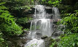
Ton Sak Yai National Park, Uttaradit Provincehas a fully developed forest area that surrounds a large waterway and numerous creeks. It is also home to significant and beautiful natural features, with well-known attractions such as Huai Niam Waterfall, Kok Mon Kaeo Waterfall, Chan Cave, Chedi Cave, Suea Dao Cave, Pha Tang Cave, and Phu Miang Mountain. It has a total area of approximately 324,241 rai or 519 square kilometers and is a popular recreation spot.
Background
On October 19th 1989 Mr Phairoch Daraphen, Forestry Officer Level 5 conducted a survey to ascertain information about the Khlong Tron Fang-Sai and Fang-Khwa National Reserved Forest, the Mueang and Nam Pat District in Uttaradit Province. According to the survey results the area consists of an entirely natural forest and numerous beautiful waterfalls such as Huai Prong Waterfall, Huai Com Waterfall, and Huai Niam Waterfalls, as well as the Khwam Ruea Mountains peak and Ngai Ruea Mountains. There is a waterway called “Khlong Tron” that connects various streams and then empties into the Nan River. Additionally, it is a National Reserved Forest. The National Park was initially named “Khlong Tron,” after the well-known waterway, but later changed its name to “Ton Sak Yai National Park.”
At the National Park Board meeting no.4 / 1994 on November 8th, 1994, it approved the establishment of a National Park was approved in 1994and it was declared a National Park on December 4th in 2003. It covers an area that incudes Nam Pat Forest, Pak Huai Chalong Forest, Huai Si Siat Forest, Khlong Tron Fang-Khwa Forest and Khlong Tron Fang-Sai Forest is located in the Saen To, Nam Khrai and Nam Phai Sub-district, Nam Pat District, Tham Chalong Sub-district, Mueang Uttaradit District, Pha Lueat Sub-district, Tha Pla District and Nam Phi, Pak Khuang and Bo Thong Sub-district, Thong Saeng Khan District in Uttaradit Province.
Along with being a large waterway with numerous creeks, there are also mportant and beautiful natural feature such as Huai Niam Waterfall, Kok Mon Kaeo Waterfall, Chan Cave, Chedi Cave, Suea Dao Cave, Pha Tang Cave, and Phu Khao Miang. It is a convenient and popular place to take a vacation. Ton Sak Yai National Park covers an area of approximately 519 square kilometers or 324,241 rai, and was made Thailand’s 103rd National Park in 2003.
Note : After paying the entrance fee to the National Park, please carry the receipt for inspection.
324240.80 rai (518.7 square kilometers)
|
|
Nature trails ⇔ Trekking ⇔ Visit Waterfall ⇔ Cave exploration/Geological condition ⇔ Observe flowers/plant ⇔ Bird , butterfly , wildlife watching activities ⇔ Stargazing ⇔ Mountain biking ⇔ Rafting ⇔ Take a boat ride or a paddle ⇔ Take a photo/Video
Welfare shop : 08.00 - 17:00 hrs.
Mobile phone signal:
National Park Headquarters area: AIS, TRUE, DTAC
|
|
The topographical features are that or a mountain range. It has prominent peaks including Khao Phu Miang, Khao Khwam Ruea, Khao Ngai Ruea, Khao Sam Liam, Khao Yuak, Khao Thanon, Khao Daet, Khao Mai Pha, Khao Tak Bon, Khao Nam Yoi, Khao Phak Khuang, and Khao Chan. The highest summit is in the east, and is called Khao Phu Miang, which is approximately1,500 meters above sea level. Most rivers flows east to west into the Nan River, including the Khlong Ma Muet Creek.
|
|
Generally, the climate is hot, especially in summer, which is in March and April. Winter lasts from October to February, and the rainy season is quite short by Thai standards. The lowest temperature is around 13 degrees Celsius and the highest in summer reaches 43 degrees Celsius.
|
|
|
|
The general forest condition is that of dry evergreen forest, hill evergreen forest, pine forest, mixed deciduous forest and deciduous dipterocarp forest. Plants found include Irvingia malayana, Hopea ferrea Laness, Anisoptera costata, Toona ciliate, Tetrameles nudiflora, Rubber, Phyllanthus emblica, Michelia champaca, Teak, Iron Wood, Burma Padauk, Lagerstroemia calyculata Kurz, Schleichera oleosa, Vitex pinnata, Terminalia chebula, Burma Sal, Burmese Sal, Hairy Keruing, Dipterocarpus tuberculatus, Cratoxylum formosum (Jacq.) , Gratoxylum formosum and Lithocarpus, including different types of cerifers.
|
How to get there by car :
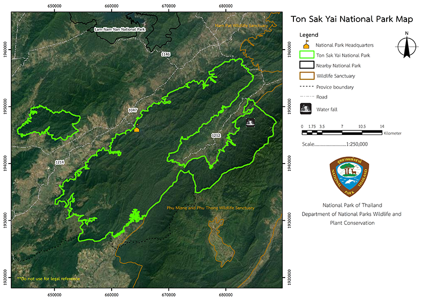
From Mueang Uttaradit District, travel along National Highway No. 11 (Phitsanulok – Den Chai) to between milestone No. 107-108 (Ban Pa Khanun intersection), where you should transfer onto the Provincial Highway No. 1047. At between milestone No. 36 – 37 visitors can visit Chan Cave, and after traveling along Provincial Highway No. 1047 for approximately 11 kilometers, they will reach the junction for the Ton Sak Yai National Park Headquarters. It is another 3 kilometers from the junction to the National Park Headquarters.
- National Park Ranger Station Kho To No. 1 (Ton Khanun)
- National Park Ranger Station Kho To No. 2 (Tham Chan)
- National Park Ranger Station Kho To No. 3 (Wang Ben)
- Accommodation – Sak Yai 201 (Pha Kluai Mai)


