Mae Sariang National Park (under gazetting)
Contact Location : Mae Yuam Fang-Sai National Reserved Forest , Ban Huai Luang, Moo 6, Ban Kasat Sub-district, Mae Sariang District Mae Hong Son Province
Telephone Number : -
Email : maesariangnationalpark16mr@gmail.com
Facebook : Mae Sariang National Park (under gazetting)
National Park Superintendent :
Position :
Information
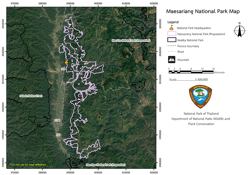
A survey area was established for the Mae Sariang National Park, which covers the Mae Yuam Fang-Sai National Reserved Forest, and the districts of Mae La Noi, Mae Sariang and Sop Moei District in Mae Hong Son Province. The total area is 120,453 rai or 193 square kilometers, and thearea is narrow, running on a north-south axis. It is approximately 50 kilometers long and 12 kilometers wide.
Territory
The northern border is adjacent to Ban Pa Mak Community Forest, Mae La Noi Sub-district, Mae La Noi District, Mae Hong Son Province.
The southern is next to the Mae Lit Stream in Sop Moei Sub-district, Sop Moei District, Mae Hong Son Province.
The eastern border is adjacent to the Ban Huai Pu community Forest in Mae Ho Sub-district, Mae Sariang District Mae Hong Son Province. and
The western border sits next to Wat Tham Phra in Ban Kat Sub-district, Mae Sariang District, Mae Hong Son Province. The area resides in 8 Sub-districts
1. Mae La Noi Sub-district, Mae La Noi District, Mae Hong Son Province
2. Tha Pa Pum Sub-district, Mae La Noi District, Mae Hong Son Province
3. Pa Pae Sub-district, Mae Sariang District, Mae Hong Son Province
4. Ban Kat Sub-district, Mae Sariang District, Mae Hong Son Province
5. Mae Ho Sub-district, Mae Sariang District, Mae Hong Son Province
6. Mae Sariang Sub-district, Mae Sariang District, Mae Hong Son Province
7. Mae Khatuan Sub-district, Sop Moei District, Mae Hong Son Province
8. Mae Suan Sub-district, Sop Moei District, Mae Hong Son Province
Background
-
Note : After paying the entrance fee to the National Park, please carry the receipt for inspection.
120,453 rai (192.7 square kilometers)
|
|
|
|
-
Welfare shop : -
Mobile phone signal:
National Park Headquarters area: AIS, TRUE
|
|
Mae Sariang National Park is located in the Mae Yuam Fang-Sai National Reserved Forest area. The area encompasses Mae La Noi, Mae Sariang, and Sop Moei District and totals 120,453 rai or 193 square kilometers. The majority of the area are forests or high mountains. The forest is evergeen and home to diverse ecosystems with significant and priceless natural resources and interesting and beautiful scenery. Approximately 95% of the park is located at elevations between 300 and 1,200 meters above sea level and there are numerous magnificent peaks such as such as Doi Chang and Doi Pha Daeng. The survey area established the Mae Sariang National Park was created by the deposition of sediment by rivers and streams and then erosion, which created the shale, sandstone, gravel, and limestone base. The area is undulating with a variety of slope gradients. The terrain is characterized by a mountain range and the soil is at the foot of the mountains is formed by shale and othereroded materials. The soil throughout the mountainous region is composed of a slightly gravelly loam. |
|
The climate is subtropical withthe highest temperatures recorded in April, when it can reach approximately 41 degrees Celsius. Winter is in December to February, and temperatures can get as low as 9 degrees Celsius. There are three seasons:
|
|
|
|
Forest Resources A mixed deciduous forest is alsosparse and also consists of mainly large and medium sized trees as well as different types of bamboo on the ground. Commonly found trees were Teak, Iron Wood, and Burma Padauk. Hill evergreen forest at elevations above 1,000 meters is considered an evergreen forest. It is home to important plants such as members of the Fagaceae family including Castanopsis diversifolia and Quercus helferiana. Ground plants such as ferns, ground orchids, and mosses are also common. This type of forest is normally found near the source of rivers. Tropical rain forest is characterized by a densely forested area that has become overgrown with a variety of plants. It is full of medium to small sized trees including several species of betel or palm trees. The forest's lower ground is densely forested with shrubs, annual plants, rattan, bamboo, and various vines that cling to tree trunks and branches. Wildlife Resources |
How to get there by car :
-
- Mae Ngao National Park Headquarters
- National Park Ranger Station Mo Ngo No. 1 (Mae Rit)
- National Park Ranger Station Mo Ngo No. 2 (Mae Ngao)
-

