Mae Tho National Park (under gazetting)
Contact Location : Mae Tho National Park (under gazett), P.O. Box 10, Hot Post Office, Hot District, Chiang Mai Province 50240
Telephone Number : (+66) 8 9526 0116
Email : maetho41@gmail.com
Facebook : Mae Tho National Park (under gazetting)
Information
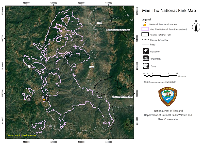
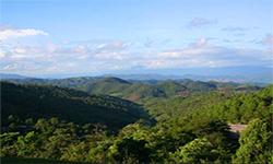
Mae Tho National Park is located on a continuous high mountain range that begins at Doi Inthanon. There are numerous and diverse forest types that are appropriate for nature walks and waterfall excursions. Mae Tho National Park is approximately 618,750 rai (990 square kilometers) in size in the district of Hot and Mae Chaem District in Chiang Mai Province.
Background
In 1974, the Royal Forest Department’s Watershed Conservation Division conducted a survey of precarious areas and the deforested areas in the upper reaches of the North. Additionally, a project to reforest degraded watershed area to restore their original forest conditions was instigated. The project consists of ten development and improvement unitsand was the sixth watershed development station no. 6 (Doi Mae Tho), established in Chiang Mai Province’s Ban Mae Tho, Moo 1, Bo Sali Sub-district, Hot District. The continued planting of forest in the high mountains had been destroyed by rivers and flash floods before 1980. As a result, a separate sub-unit was relocated to Mae Tuen Sub-district, Omkoi District, Chiang Mai Province, to plant a forest which would be fully developed in accordance with the forest management program.
In 1991, the Royal Forest Department directed officials to conduct a survey of watershed development station no. 6 and surrounding areas in preparing for the establishment of a National Park. It was given the “ame "Mae Tho National ”ark,"’and would include Khun Mae Lai National Reserved Forest, Hot District in Chiang Mai Province, and Mae Chaem National Reserved Forest, Hot District in Chiang Mai Province was proposed to the National Park Board. This was approved the Royal Forest Department to conduct a survey in order to establish in November 2nd 1993 and it covers 990 square kilometers, or 618,750 rai.
Note : After paying the entrance fee to the National Park, please carry the receipt for inspection
274,281.65 rai (438.85 square kilometer)
|
|
|
|
|
|
Nature trails ⇔ Trekking ⇔ Plants watching ⇔ Visit Waterfall ⇔ Swimming ⇔ Relax in a nature
Welfare shop : 08.30 - 16:30 hrs.
Mobile phone signal:
National Park Headquarters area: AIS, TRUE
|
|
The National Park in Mae Tho is between the latitudes of 18 degrees, 07 minutes and 18 degrees, 29 minutes in north, and 98 degrees, 8.5 minutes and 98 degrees, 24 minutes in east, there is an area. It covers an area of 990 square kilometers or 618,750 rai, it is located in Mae Lai National Reserved Forest in Hot District, and Mae Chaem National Reserved Forest in Mae Chaem District, Chiang Mai Province. Mae Tho National Park Headquarterslocated in Watershed Development Station 6 (Doi Mae Tho), which was previously known as Ban Lao Li, Moo. 9 (a village distinct from Ban Mae Tho Moo 1), Bo Sali, Hot District in Chiang Mai Province. Mae Tho National Park has tower karsts and complex mountains landscape in the mountainous terrain on a north-south path, parallel to the Doi Inthanon mountains. It is at an elevation of 400 to 1,699 meters above sea level and and has steeper slopes on the north side with a 20–48% gradient, while the south only has 15-20% gradients at an average elevation of about 1,000 meters above sea level. The highest summit is Yot Doi Kio Rai Hmong, standing at 1,699 meters above sea level in the Ban Pang Hin Fon , Pang Hin Fon Sub-district, Mae Chaem District, in Chiang Mai Province. The Mae Tho National Park Headquarters located approximately 1,200 meters above sea level. |
|
The climate is classified into three seasons: the rainy season, which runs from May to September, and has an average temperature of 25 degrees Celsius, the winter season, which has an average temperature of 10 degrees Celsius and he average temperature in the summer, between March and April, is 30 degrees Celsius. It can get very cold for Thailand, with lows of 4 degrees possible, but the average annual temperature is approximately 27 degrees Celsius, and the average annual rainfall is approximately 1,030 mm.
|
|
|
|
Mae Tho National’Park's forest species and plants are dominated by tropical rain forests on the’park's northern boundary in Mae Chaem District. Common plants are Hopea odorata, Dipterocarpus, Michelia champaca, Toona ciliata, Mangifera caloneura Kurz, Bischofia javanica, Garuga pinnata Roxb, Davil tree, and the lower ground plants consisting of Bottle Gourd, Betel Pepper, Ginkgo biloba and Boesenbergia sp. hill evergreen forest is found at an altitude of 800 to 1,400 meters above sea level. Important plants include thethe Quercus kerrii Craib, Evergreen Chinkapin, Quercus helferiana, Melanorrhoea Usitata, Orange Chathea. The ground plants in the hill consists of Carex baccans Nees, Pigeon pea, Aglaia edulis (Roxb.) Wall, Crofton Weed and more. The mixed deciduous forest, commonly found alternating with hill evergreen forest and is home to Teak, Xylia xylocarpa, Burma Padauk, Bungor, Thai Bungor, Anogeissus acuminata, Dipterocarpus, and its ground plants consist of bamboo and grass. The Pine Forest and Deciduous dipterocarp Forest are mostly found in the Hot District, although sometimes it is mixed with the deciduous dipterocarp forest. The primary plants are Pinus kesiya, Evergreen Chinkapin, Memecylon edule, Red Zebra Wood, Siamese Sal, Burmese Sal, Hairy Keruing, Dipterocarpus tuberculatus, Arundinaria pusilla, Arundinaria cililta, and other grasses. Important wildlife species include Gaur, Wild Deer, Serows, Indian Muntjac, Asiatic Black ear, Gibbons, Monkeys, Langur, Common Palm Civet, Burmese Hare, Wild Boars, and Wild Elephants, all of which frequently migrate to the Om Koi wildlife sanctuary. Dong Sam Muen, in Mae Pai Forestis home to a variety of birds, including peacocks, various species of pheasant, wildfowl, and parrots, as well as Myna, Blue Magpie, falcons, and the Woodpecker. Reptiles include Reticulated Python, Burmese Python, Cobra, Clouded Monitor Lizard, Ground Lizard, and the Soft-Shelled Turtle. Amphibians include frogs and a variety of other amphibians withfish is unexplored. |
How to get there by car :
From Chiang Mai city, travel 89 kilometers along National Highway No. 108 (Chiang Mai-Hot) to Hot District, then 54 kilometers along National Highway No. 108 (Hot-Mae Sariang). After that, bear right onto provincial highway no. 1270 (Ban Khong Loi-Ban Mae Tho), and go for a distance of 16 kilometers to the junction with the Mae Tho National Park Headquarters
- National Park Ranger Station Mo To 1 (Choeng Pha)
- National Park Ranger Station Mo To 2 (Salak Hin)
- National Park Ranger Station Mo To 3 (Mai Thung Son)
- National Park Ranger Station Mo To 4 (Huai Bong)
- Non Resrve


