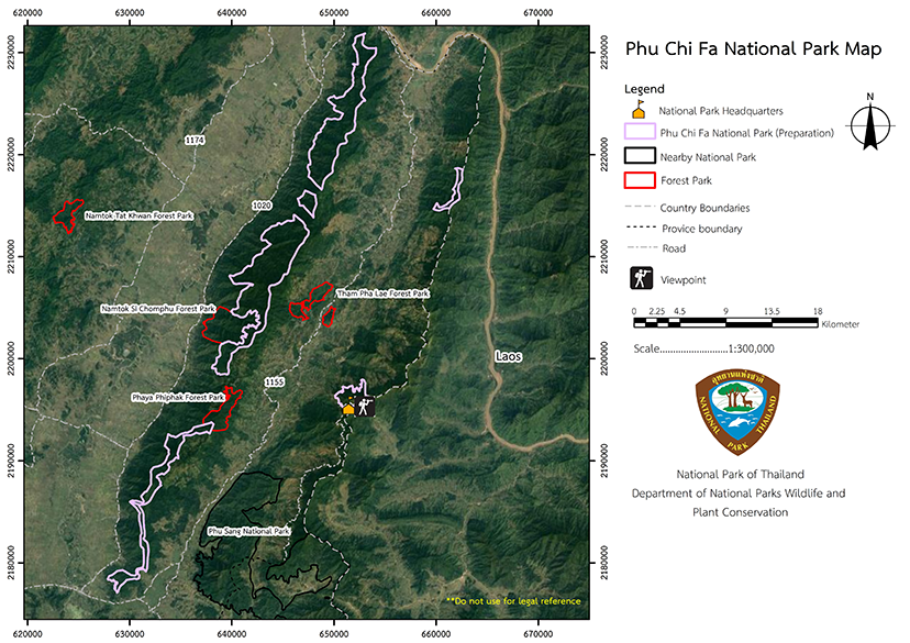
Phu Chi Fa National Park (under gazetting)
Contact Location : Phu Chi Fa National Park (under gazetting), 43/1 Moo 24, Tap Tao Sub-district, Thoeng District, Chiang Rai Province
Telephone Number : (+66) 8 4807 9848 , (+66) 8 1718 6761
Email : Phuchifa2020@gmail.com
Facebook : Phu Chi Fa National Park
Information
The National Reserved Forest areas being surveyed are between latitudes of 19 degrees, 39 minutes, 58 seconds and 20 degrees, 9 minutes, 36 seconds and longitudes of 100 degrees, 11 minutes, 32 minutes and 100 degrees, 34 minutes, 43 seconds, covering the total area of 120,000 rai, or 192 square kilometers, in four districts in Chiang Rai Province: Thoeng, Wiang Kaen, Khun Tan, and Chiang Khong District. The location is as follows:
The North is adjacent to the Lao People's Democratic Republic.
The East is adjacent to the Lao People's Democratic Republic.
The South is adjacent to Thoeng District, Chiang Rai Province, and Phu Sang District, Phayao Province.
The West is adjacent to Thoeng, Khun Tan, and Chiang Khong District, Chiang Rai Province.
Background
Non
Note : After paying the entrance fee to the National Park, please carry the receipt for inspection.
58,069.24 rai
|
|
|
Nature trails ⇔ Camping
Welfare shop : Non
National Park Headquarters : AIS
|
|
The three national reserved forest consist primarily of plains with low hills and tower karst mountains interspersed throughout. There is also mountainous terrain which runs north-south and has slope between 30-70 degrees with an elevation of 400 to 1,700 meters above sea level. It is the source of numerous waterways, including the Ngao Stream, Luek Creek, Chomphu Creek, Pa Daeng Creek, Khu Creek, and Han Creek. Additionally, it empties into two major rivers, which arethe Ngao River, which leads to the the Ing River in Thoeng District and eventually the Mekong Riverin Ban Pak Ing in Chiang Rai province's Chiang Khong District. The Ngao River flows northward and flows into the Mekong River near Ban Huai Luek, in Wiang Kaen District, Chiang Rai Province.
|
|
This area has a tropical monsoon climate as during the rainy season, it is influenced by the southeast monsoon, while in the winter, it is influenced by the northeast monsoon. Each year, the average minimum temperature is approximately 7.5 degrees Celsius with average highs of approximately 37.7 degrees Celsius. Annual rainfall averages 1,985 mm and there are 3 seasons:
|
|
|
|
Forest Condition: 2. Deciduous Dipterocarp forest are found throughout the area, mostly interspersed with mixed deciduous forests. Burma Sal, Burmese Sal, Hairy Keruing, Dipterocarpus tuberculatus, White - Meranti, Irvingia malayana are some of the more notable plants located there, and Gigantochloa albociliata Munro, Kaempfer, and White Angel are common on lower ground 4. Coniferous forest (Pine Forest) is a type of forest found along ridges and on the high mountain summits. They are scattered throughout the area and not perceived as one large forest area, and are frequently found in conjunction with hill evergreen forest and mixed deciduous forest. The Benguet Pine is the dominant species found. Wildlife: 1. The most common bird groups include Coucals (Centropus spp), White-rumped Sharma, Magpies (Copsychus alabaricus), Black-Headed Bulbul (Psynonotus blanford), Red Junglefowl (Gallus gallus), Hoopoe (Garrulax spp.), Apus affinis, Hawks, Barn Owls, Mynas, Robins, Orioles, Mynas, Drongo, Short-Eared Owl, and many types of warblers, 3. Reptiles include the Siamese Big-headed Terrapin, various snakes, Tokay Gecko, Lizards, Skink, Clouded Monitor, Sunda Pangolin, Eastern Bent-toed Gecko, Ground Lizard, Centipede, Millipede, Flying Dragon, Scorpion, and more. |
How to get there by car :
- To get to the park from Thoeng district, travel approximately 6 kilometers north on Highway No. 1021 to the intersection with Highway No. 1155. It is approximately 28 kilometers down the rural highway road connection at Mu Ban Ratchaphat Di. Then proceed approximately 9 kilometers to the intersection with Highway No. 1093, and from there is approximately 2 kilometers to the Phu Chi Fa National Park Headquarters (under gazetting).
- From the Phu Sang District, take the rural road to Pho Yo 4010 for approximately 9 kilometers from the Highway No. 1093 junction, and then approximately 46 kilometers to the intersection. From there it is approximately 1.5 kilometers to the Phu Chi Fa National Park Headquarters (under gazetting).
- From Wiang Kaen District, travel approximately 16 kilometers north on Highway No. 1155 to the intersection. Rural Road Cho Ro 4029 is located approximately 13 kilometers from the Highway No. 1093 intersection and the junction for the Phu Chi Fa National Park Headquarters is approximately 24 kilometers away (under gazetting).
Non Agency
Non Reserve


