Mae Wong National Park
Contact Location : Mae Wong National Park, milestone No. 65, Khlong Lan District, Kamphaeng Phet Province 62180
Telephone Number : (+66) 9 0457 9291 , (+66) 9 8797 3197
Email : maewong_np@hotmail.com
Facebook : Mae Wong National Park
Information
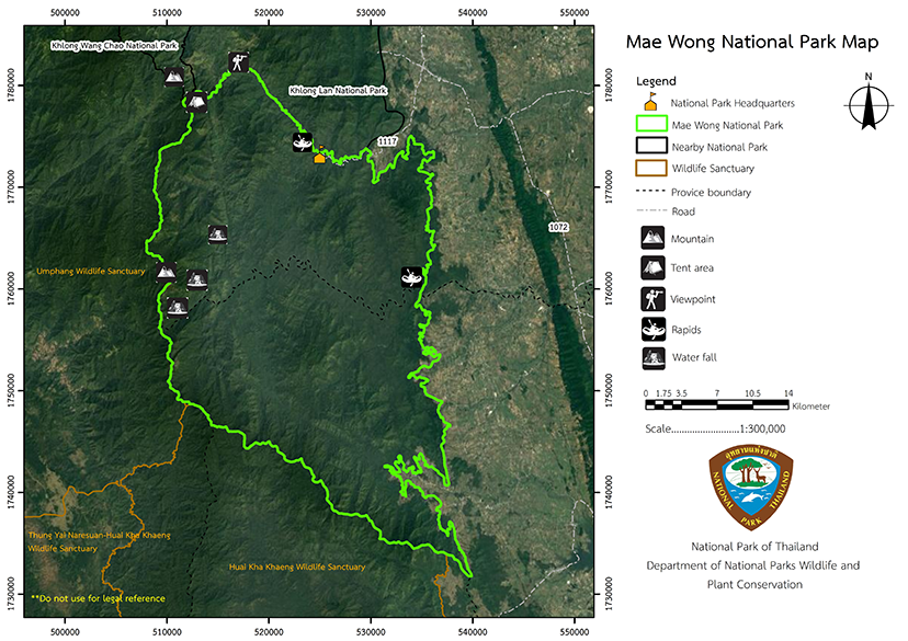
Mae Wong National Park encompasses the districts of Pang Sila Thong District, Kamphaeng Phet Province, and Mae Wong District, as well as a minor district of Mae Poen in Nakhon Sawan Province. The majority of the site is dedicated to the stream’s source, and five beautiful waterfalls are featured along the tower karst mountains from the source of the vital Mae Wong River. Along this ravine, there are also rocky rapids that form a small cascade. The total area of the park is 558,750 rai or 894 square kilometers.
Background
Mr. Sawat Khamprakob, Minister of the Prime Minister’s Office, sent a letter from the Prime Minister’s Office, no. No Ro 0104/9871 dated August 2, 1983 to Dr. Thaloeng Thamrongnawasawat, Permanent Secretary of the Ministry of Agriculture and Cooperatives, requesting Mae Wong-Mae Poen Forest area in Nakhon Sawan Province to be protected and be designated as a national park. The Department of Forestry then issued an order no. 1290/2526 on August 26th, 1983 to have Mr. Chainarong Chantarasarntoon, forestry technical officer level 4, conducted an area survey.
The majority of the area is high mountains that serve as the Mae Wong River's headwaters. The Mae Krasa or Mae Ki waterfall, which is approximately 200 meters high, is a work of natural beauty in its own right. There are numerous cliffs, as well as lush forest habitats teeming with a diverse array of plants and wildlife. It was deemed appropriate to establish it as a National Park according to the survey report no. Ko So 0713/special on 19 December 1983.
National Park Division, Royal Forest Department made a presentation to the National Park Board and the area was designated a National Park on April 2, 1985. A royal decree establishing Khlong Khlung Forest and Khlong Mae Wong Forest in the Pang Ta Wai, Khlong Khlung District (Pang Sila Thong district), Kamphaeng Phet Province and Mae Wong-Mae Poen Forest in Mae Le and Huai Nam Hom Sub-district, Lat Yao District, Nakhon Sawan Province (Currently, it is Mae Le Sub-district, Mae Wong District, and Mae Poen District) Mae Poen Minor District were to become a National Park on September 14th, 1987, and became Thailand’s 54th National Park.
Note : After paying the entrance fee to the National Park, please carry the receipt for inspection.
558,750 rai (894 square kilometers)
|
|
|
|
|
|
|
|
|
|
|
|
|
|
|
Nature trails ⇔Trekking ⇔ visit Waterfall ⇔ Observe flowers/plant ⇔ Bird ,butterfly ⇔ stargazing ⇔ Camping ⇔ Mountain biking
Welfare shop : Open daily from 8.30 – 16.30 hrs.
National Park Headquarters : AIS
|
|
The topographical features consists of a fold mountains (complex mountain) that run parallel to Thanon Thongchai Motuian range and descend to a plain at an altitude of 50 meters. Mokochu, the highest summit, is 1,964 meters above sea level. The park features the headwaters of the Mae Wong River. There are few plains, most of which are located along the river, and they are an important source of minerals such as Mica.
|
|
Mae Wong National Park's climate is pleasant during the winter months of November to February, so that is the best time to travel. The weather is quite cold at that time due to a high-pressure zone that originates in China and extends southward into upper Thailand, eventually covering the entire country. The Northeast monsoon blows into Thailand during this season. The coldest month is January, when the temperature drops to about 8.9 degrees Celsius. The the summer season lasts from March to May, with April's maximum temperature being 38.1 degrees Celsius. This climate produces a deciduous dipterocarp forest and mixed deciduous forest ecosystem. The rainy season, which lasts from June to October, averages 1,100 millimeters of rainfall per year.
|
|
|
|
Its plants and wildlife are classified in the following ways:
|
How to get there by car :
Proceed to the headquarters of Mae Wong National Park by taking National Highway 1 out of Nakhon Sawan, to the Wilai Intersection. At milestone No 307 + 500, bear left onto Provincial Highway No. 1242 for approximately 40 kilometers (passing through Pang Silathong District). Then bear right onto Provincial Highway 1072 for an additional ten kilometers to the Khlong Lan intersection. Turn left onto Provincial Highway No. 1117, Khlong Lan - Um Phang Road, and travel approximately 15 kilometers to the Mae Wong National Park Headquarters, which serves as the location of accommodation zone 1 (the National Park Headquarters zone) and the gateway to villa zone 2. (Chong zone).
- Mae Wong National Park Ranger Station No. Mo Wo 1 (Checkpoint Km.57th)
- Mae Wong National Park Ranger Station Mo Wo No. 2 (Pang Khao San)
- Mae Wong National Park Ranger Station Mo Wo No. 3 (Khao Khiao)
- Mae Wong National Park Ranger Station Mo Wo No. 4 (Mae Rewa)
- Mae Wong National Park Ranger Station Mo Wo No. 5 (Pang Sak)
- Mae Wong National Park Ranger Station Mo Wo No. 6 (Sap Ta Ming)
- Mae Wong National Park Ranger Station Mo Wo No. 7 (Khlong Suea Kham)
- Khun Nam Yen Watershed Management Station
- Mae Wong 101 (Wong Wana 3)
- Mae Wong 104 (Wong Wana 5)
- Mae Wong 201/1 (Chong Yen 1)
- Mae Wong 201/2 (Chong Yen 1)
- Mae Wong 201/3 (Chong Yen 1)
- Mae Wong 201/4 (Chong Yen 1)
- Mae Wong 201/5 (Chong Yen 1)
- Mae Wong 301 (Mae Rewa 1)
- Mae Wong 302 (Mae Rewa 2)


